Drones four times faster at scanning car crashes than old methods

A recent study conducted by the North Carolina Department of Transportation (NCDOT) revealed that drones could expedite the state’s investigation of traffic collisions.
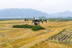
In the study, published in August, the state’s Division of Aviation flight team tested three models of unmanned aircraft systems (UAS), also known as drones — DJI Mavic Pro, DJI Phantom 4 Pro, and DJI Inspire 2 — which range in accuracy and affordability. The images recorded by the drones were then processed by Agisoft Photoscan software and compared to the NCDOT’s current laser scanning technology. In all three drone tests, the technology was able to record and analyze the staged crashes in under 25 minutes — a significant improvement from traditional laser methods that take up to 1 hour 51 minutes to complete.
The study also found that the data produced by drone is “easy to read” and provided accurate maps of the collision site. According to the study, the overall accuracy of the measured locations was found to be within 0.03 feet.
“Based on these findings, we believe that time spent at collision sites can be dramatically reduced by using drones, allowing for rapid restoration of traffic flow and the safety of investigative members,” the N.C. State Highway Patrol stated.
In addition to time and safety benefits, the study found that the drone technology was easy to operate and required less maintenance than other methods.
The test flights conducted by NCDOT were all performed in daylight under clear weather conditions, however. The quality of the drones’ scans in less preferable conditions has yet to be tested by the state.
Despite this factor, the NCDOT still strongly recommends that the North Carolina State Highway Patrol integrate drones into its collision scene reconstruction units to help improve the safety and efficiency of the state’s roadway system, the study stated.
This work makes North Carolina a member of a growing number of state governments to examine the use of drones to save time and improve efficiency of operations. Minnesota and Ohio are both testing the use of drones to scan bridges, the New York Police Department used drones to monitor traffic at the state fair in August, and Virginia opened one of its runways to larger unmanned systems in May.
And as researchers like those at MIT search for new ways to augment public safety operations — like through the development of drone designed to fly for up to five days without landing — federal testing sites like the ones in Nevada help establish regulatory policy for low-altitude flights that may someday include local government oversight.