Drones and explosives — How Alaska is using technology to manage extreme weather events

Alaska’s landscape and topography — with its towering mountain ranges, vast boreal forests, immense tundra, millions of lakes, glaciers, volcanic activity and the continent’s longest coastline — present a unique challenge when it comes to emergency management during extreme weather events.
From locating avalanche victims to assessing unstable snow and supporting disaster recovery across vast, remote areas, drones and remote control systems are becoming a critical tool for keeping residents and first responders safe.
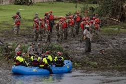
Shannon McCarthy, communications director at the state’s transportation department, said that drones proved particularly useful during Typhoon Halong, which devastated the Alaska’s remote Yukon-Kuskokwim Delta last October with 107 mph winds and record storm surges, destroyed more than 200 homes and damaged hundreds more.
“What we have seen in the last couple of years is that we’re getting earlier and stronger storms hitting our West Coast,” McCarthy said in an interview. “So, we’ve been honing our skills in terms of disaster response or recovery. Even though DOT is the largest department in the state of Alaska, we are actually still really small, so we’re trying to leverage technology so that we can respond quicker and more efficiently.”
In 2024, the department received a $12.4 million SMART Grant from the federal Department of Transportation to fund initiatives supporting the use of drones for rural infrastructure inspection and emergency response. Alaska had obtained a specialized Federal Aviation Administration waiver the previous year for advanced drone testing.
McCarthy said the transportation department used drones and Starlink panels, user terminal antennas receive internet from SpaceX’s satellite constellation, to survey 35 rural communities, collecting 98,000 images and 540 videos, totaling 5 terabytes of data.
“We actually pre-positioned some of our drone operators in rural Alaska so when the storm passed, we were able to get 10 teams into the field and and actually fly over 35 of our communities,” McCarthy said. “And these are very rural communities are hard to get to, but we because we were pre staged there with equipment, we were able to start the recovery process almost right away.”
The department determined the catastrophic storm had flooded at least 15 Yup’ik communities, such as Native Alaskan villages like Kipnuk and Kwigillingok, with at least 470 homes sustaining major damage. The storm not only forced widespread evacuations, it created an infrastructure crisis just before the start of Alaskan winter, including airport repairs, boardwalk reconstruction, as well as damage to water and sewer systems.
McCarthy said the department integrated the data collected from more than 300 drone flights into databases managed by the Federal Emergency Management Agency, which helped it more quickly apply for emergency work authorizations.
“People in these rural and remote communities could qualify for FEMA assistance, but if you’re really rural and remote, you may not have the same technology [that’s] available in urban areas, so sometimes you are not able to apply and get the funding you need,” McCarthy said.
Though the state’s emergency declaration ended on Jan. 7, she said, the recovery efforts continue because many areas still lack consistent electricity and water, and there is still damage to important roadways and boardwalks.
‘Can’t control nature’
In addition to its diverse topography, avalanches in Alaska also present a unique threat to infrastructure and rural communities due to the state having both maritime climates and continental climates.
Maritime, also called coastal, climates have mild temperatures, cool summers, warm winters and more precipitation because water heats and cools slowly. Continental, or inland, climates have more extreme temperature swings, with hot summers, cold winters, and often less precipitation because land heats and cools quickly.
The state experiences loose snow avalanches, brought on by rainwater weakening the snowpack, as well as glide avalanches, when the snowpack slowly moves down slope. Timothy Glassett, who works as an avalanche and artillery program manager for the state DOT, said of all the avalanches that occur in Alaska, slab avalanches, triggered by strong wind and storms, are the most dangerous and unpredictable.
“You need a couple ingredients for avalanches to pose a risk to the traveling public or state employees. You need significant terrain that’s deep enough to slide. You need snow on the ground, you need snow that is reactive to sliding, and you need weather to contribute to that,” he said.
Glassett said Alaska’s transportation department uses drones for both long-term preventative measures, like mapping avalanche-prone areas in order to build barriers that hold back snow from reaching roadways and bridges, as well as for explosive mitigation, triggering small snow slides using explosives, to prevent dangerous, large-scale natural avalanches.
“We try not to use the word control, because we can’t really control nature, but we do our best to mitigate the avalanche risk,” Glassett said. “And the idea, similar to wildfire, is to when we have a closed roadway, to trigger avalanches preventatively, so that we are removing some of the snow volume in the starting zone and decreasing the volume of natural avalanche activity.”
‘Fast aerial assessment’
In 2023, Glassett said his team commissioned a private company based in Utah to evaluate the state’s avalanche risk based on the Avalanche Hazard Index, a score that shows how dangerous a road is by estimating how often avalanches could hit cars and how serious the damage or risk to people would be, helping officials decide where safety measures are most needed.
Based on the report, the department then began surveying the state’s most avalanche-prone areas, including Juneau, Thompson Pass in southeastern Alaska and the Kenai Peninsula in the southcentral region of the state.
“We can get a very quick, fast aerial assessment of what’s going on. It really helps with emergency response, because we’re not having to contract with helicopters and try to work through their schedule. So it’s it’s been a game changer that’s increased our response time and our assessment ability,” Glassett said of the department’s drone use.
Another benefit of drones, he said, is their thermal imaging capability, used to aid in search and rescue missions if people or debris get trapped on mountains or underneath densely packed snow.
“You can search that area and see if there’s any heat signatures,” Glassett said. “It could be a running vehicle, it could be personnel, and then make your assessment from there to go in there and potentially probe the debris with avalanche probes and see if there’s something buried.”
As Alaska looks to the future of emergency management and avalanche mitigation, Glassett said, the department hopes eventually to adopt technology that can detect ongoing avalanches using infrasound devices, which can detect sound waves below the lower limit of the human ear, or Doppler radar.
“We’re hoping to integrate closure gates, passive technology on the roadside looking up at an avalanche path and detecting an avalanche in motion,” he said, “and then directly send a signal to either warning lights on the roadway or closure gates and closing the road before public is impacted by that avalanche.”