National States Geographic Information Council (NSGIC)
Minnesota mapping official to lead NSGIC on interim basis
Dan Ross, who's leaving state government in January, will temporarily serve as NSGIC's executive director.
New study looks for GIS gaps in 911 systems
The federal government's National 911 Program and Mission Critical Partners are assessing which jurisdictions need help with their geospatial data technology.
North Carolina is preparing for a $1 billion broadband push
Officials said to allocate the funding effectively, they'll need more-accurate data.
Mapping service for state and local government included in Biden's climate order
A new federal mapping service would assist federal, state, local and tribal governments in their climate planning and resilience activities.
GIS data will be critical for successful vaccine distribution
GIS data will enable states and localities to determine where COVID-19 vaccines are needed as they become available, an Esri expert said during a webinar.
How Maryland used GIS to build its COVID-19 response website
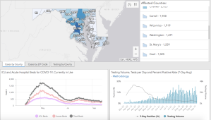
Julia Fischer, Maryland’s geographic information officer, said many agencies didn't know how powerful GIS could be when the state began building its informational portal in March.
COVID-19 gave GIS, elections leaders chance to ‘think outside the box’
While the pandemic presented significant challenges for the Geo-Enabled Elections project, it also prompted leaders to think differently.
In virtual conference, NSGIC to highlight GIS in COVID-19 response
The organization’s first fully virtual conference will kick off next week and highlight the role of GIS in COVID-19 response across state governments.
States need to improve for national GIS infrastructure to work, report says
A new report card on state GIS performance shows weak links that the National States Geographic Information Council says need to be repaired.