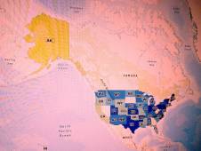
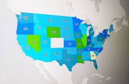
States are making steady progress on GIS and facing old challenges, according to the latest report from the National States Geographic Information Council.
On the Priorities Podcast, Kansas IT chief DeAngela Burns-Wallace talks about how cyber fits into her top priorities, and NSGIC’s Jenna Leveille and Dan Ross on the…
Smith, who helped get the federal Geospatial Data Act passed, will serve in a newly created role at the National States Geographic Information Council.
A map shared by Shasta County, California, officials during a presentation on May 6, 2021, reveals the typical pencil-and-paper processes that once defined elections operations in the local government. (Shasta County, California)
County officials said a recent pilot project with the National States Geographic Information Council gave them a boost in confidence and staff support.
State GIS leaders need to work together with their federal counterparts in order to advance the national spatial data infrastructure, NSGIC’s president says.