Tornado’s path included in Tennessee county’s new GIS map layer

After an EF3 tornado ripped through Clarksville-Montgomery County, Tennessee, on Saturday, damaging hundreds of homes and killing three people, the county’s Assessor of Property office on Monday released a new map layer for its geographic information systems application that includes data on the tornado’s path and which properties were affected.
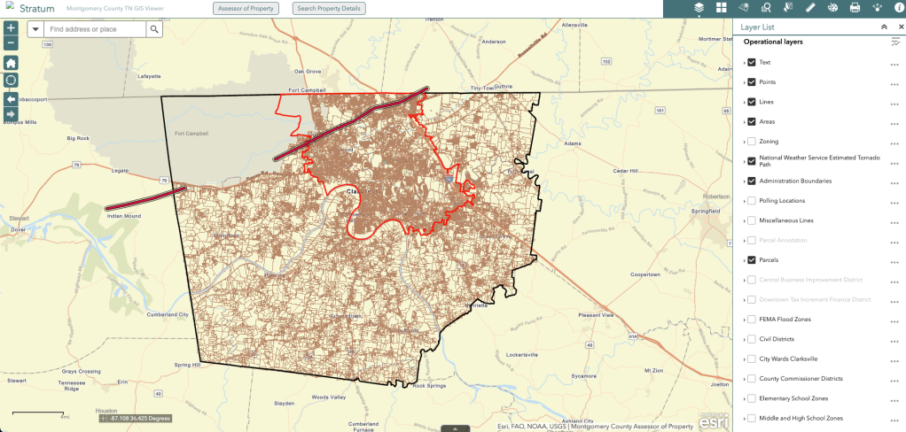
The map layer, according to a Facebook post from Montgomery County Assessor of Property Erinne Hester, was created using data from the National Weather Service’s radar. It depicts the path of destruction, which was 2,000 feet wide, overlaid on data about property lines. Other map layers include school zones, voting districts and recent satellite imagery.
In an email to StateScoop, Hester wrote that the map and its new layer — which was created by Jeff Young, the county’s GIS and land records supervisor, and Mick Cseri, the county’s GIS manager — has been used by volunteer efforts to “strategically locate centralized areas for food trucks, bus drop off points for volunteers, and other staging needs.”
Hester said that the new tornado path layer could also be useful for insurance companies, home repair companies, engineers, surveyors and appraisers in the coming weeks to assist with recovery efforts.
The application, which Hester said the county created in 2015, enables the office to meet its requirement of maintaining an up-to-date set of maps that display all of the parcels in the county. The application reflects the office’s master digital map and is regularly updated to reflect new subdivisions, surveys and property splits. It also features aerial images taken by aircraft flyovers dating back to 2014, which allows users to see changes in the county over the last 10 years.
Hester said the vendor that collects the aerial imagery is planning to fly over the areas hit by the tornado at no cost to local taxpayers and that the county should have the new images as soon as this week.
“Montgomery County is fortunate. In the same spirit the entire town is out helping their neighbor, we have a dedicated group of employees who want to use their talents to help where they can,” Hester said. “This new layer is exactly that — a tool that two talented county employees worked together to create for the benefit of the community. It’s a gratifying and humbling thing to be part of this community and part of this county government.”
Nearly 1,000 homes were impacted by the tornado in Clarksville-Montgomery County. According to the latest tally from the Montgomery County Emergency Management Agency, 114 homes were destroyed in Saturday’s tornado and another 857 were damaged. The information was first reported by Clarksville Now.
The National Weather Service’s preliminary storm report about the tornado, which was issued on Monday, said that the tornado was on the ground for 11.3 miles in Tennessee with winds of 150 mph before it crossed the state line into Kentucky, where it traveled for another 18 miles as an EF2 tornado.
The tornado outbreak across Middle Tennessee killed at least six people on Saturday, including a 10-year-old boy. In Clarksville, at least 62 people were injured, with nine sustaining critical injuries, according to Clarksville Now.