Rows of heavily damaged homes are seen in the aftermath of a tornado on December 10, 2023 in Clarksville, Tennessee. Multiple long-track tornadoes were reported in northwest Tennessee on Dec. 9, 2023, causing deaths, injuries and widespread damage. (Jon Cherry / Getty Images)
Officials in Clarksville-Montgomery County, Tennessee, published a new map layer that shows the path of a tornado that recently ripped through the region.
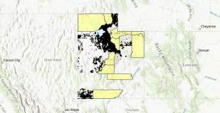
A screenshot of Utah’s Property Values Tool, which can be accessed at: https://transparent.utah.gov/property.php. Areas in yellow indicate counties that have not yet submitted data for inclusion in the statewide database.