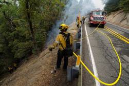
As wildfire season ramps up, Sonoma County, Calif., feels prepared

As wildfire season ramps up, the Sonoma County Public Safety Consortium in California, comprised of law enforcement, fire and emergency medical service agencies, seems poised to handle the challenge of keeping communities safe, thanks to the development of its interagency communication and data platform.
The consortium provides IT systems, including computer-aided dispatch records management systems and mobile data technology, so local agencies can stay connected and informed during emergencies and natural disasters, like floods and wildfires.
Bret Sackett, executive director of the consortium, said the Tubbs Fire in 2017, one of the most devastating wildfires the county has experienced, which destroyed more than 5,600 structures and killed at least 22 people, highlighted the need for a more coordinated effort.
“Unfortunately, that wasn’t the end of it for us, because then we had three additional major wildfires over the next four years,” Sackett told StateScoop in a recent interview. “And really from there, the fire services and emergency services for Sonoma County really took a lead role in wildfire prevention and response plans.”
The county’s preparation comes as the state keeps watch — the National Interagency Fire Center last week released a report forecasting higher-than-usual wildfire risks across much of California from summer through the fall, due to hot, dry weather conditions, as well as an abundance of dry brush vegetation.
Established in 2008, the consortium, Sackett said, evolved from a need for better interagency communication after the 1999 kidnapping case of Polly Klaas, in which a police officer interacted with Klaas’ kidnapper, but was unaware of the crime at the time of contact.
“It really made the law enforcement leaders really think there’s got to be a better way to do this, that we can be more communicative on a shared platform,” Sackett said.
Sackett said the consortium’s computer-aided dispatch system is now used daily by almost 400 public safety personnel in dispatch centers, patrol vehicles, fire apparatus and ambulances throughout Sonoma County.
He said the system, which helps agencies better manage situational awareness, also acts as the backbone of the county’s technology ecosystem, allowing other third-party technologies, such as GIS mapping to easily integrate, which has allowed officials to develop stronger evacuation plans for their unique terrain.
“We have created kind of predetermined evacuation routes. We’re kind of a unique county in terms of being in a valley, but also quite rural with a lot of kind of rolling hills, so we can quickly draw areas around locations that we want to notify and we can send out alerts,” Sackett said.
He added that the consortium also uses wildfire data to educate the county residents, build more resilient infrastructure, and manage the large amount short-term rentals frequented by tourists visiting wine country.
“We have a huge footprint of Airbnbs and Vrbos, so we require them to actually have documentation in those locations, saying ‘Hey, this is a wildfire-prone area. Here is the zone that you’re in,” he said. “Here’s your closest evacuation route. Here’s how you’re going to get notified. Here’s where to go for additional information.'”