GIS Day 2018 highlights importance of collaboration

GIS Day is hosted by organizations around the world each November chiefly as an educational and awareness event for geographic information systems, but state and local government agencies are also seizing this year on the chance to advance inter-government collaboration around geospatial data.
Washington state GIS Coordinator Joanne Markert told StateScoop on Wednesday that this GIS Day comes as her office shares a newly condensed statewide GIS plan that emphasizes improved communication, sustainable funding and data-sharing.
“It’s easy to get distracted by the everyday business, so by having something like this, we meet about quarterly to look at these [goals] and really take steps toward meeting them,” Markert said. “As much as we’ve talked about [the state’s GIS resources], there are still agencies that maybe aren’t taking advantage of it.”
Getting more agencies across all levels of government to avail themselves of already-available GIS resources is one the chief aims of officials like Markert and of events like GIS Day, which was created by geospatial data company Esri in 1999. Los Angeles County’s geographic information officer, Steven Steinberg, told StateScoop in an email that his office’s primary goal on GIS Day is to “share with our fellow county employees, collaborators and community at large how we use GIS to improve planning and decision-making across our many county departments and operations.” Whether it’s LA County, Washington or any of the hundreds of other localities participating, GIS Day is a chance for government’s stewards of geospatial data to highlight the importance of their daily work and the value it can bring if only more people would recognize and embrace it.
A ‘perfect’ STEM tool
Through partnership with the Washington State Geographic Information Council, Markert said her office is working with other state agencies, county-level entities and higher education institutions to ensure everyone has access to GIS data and to develop the state’s new strategic plan for light detection and ranging, or lidar, which she said she expects to be finished early next year.
Washington’s GIS awareness campaign spans from getting other state agencies to use the resources to partnering with universities and grade schools to create a pipeline of students who are familiar with and skilled with mapping technologies. Though Washington has participated in GIS Day for years, this is the first year the state’s technology agency will host a GIS competition for high school and middle school students. Students are encouraged to develop story maps, visualizations that combine maps, data, and written narrative, to compete for a slot in a national GIS competition hosted by Esri.
Markert said her office is gunning for Minnesota, which has traditionally done well in national GIS competitions. (Esri’s GIS Day website shows there are at least 11 events hosted throughout Minnesota this year, including GIS Fest, a series of exhibitions and presentations hosted by the University of Minnesota Duluth.)
But ultimately, GIS Day competitions like Washington’s aren’t to exert dominance over other states, but to advance education and awareness and plant seeds in the workforce for a growing industry. A 2017 study by Prescient & Strategic Intelligence projects that the global GIS market will continue to grow at a compounded annual growth rate of about 10 percent to reach $17 billion by 2023. But a lot of students don’t even know what GIS is, Markert said.
“That’s part of the purpose of this is to expand the horizon,” she said. “It’s really the perfect STEM tool because it cuts across that multidisciplinary and cuts across science and integrates technology.”
Supporting the Washington State Office of Superintendent of Public Instruction, Markert is a co-coordinator of a project to help schools install GIS software and get trained in how to use it. As valuable as this technology is, Markert said, schools need both encouragement and help to adopt it.
“That’s actually a pretty heavy lift for a lot of teachers and the point of this is to find GIS professionals who would like to donate some of their time to helping out these schools and students and being able to use the technology,” Markert said.
Uniform data layers
Collaboration has long been at the core of the GIS discipline, and was the driving force behind passage of the Geospatial Data Act in October. The legislation was created in recognition of a longstanding need to tighten standards and encourage cooperation across agencies at various levels of government so as to eliminate much of the duplicative work done today.
More than just to eliminate duplication, collaboration in GIS is often needed to validate data accuracy. Shelby Johnson, Arkansas’ geographic information officer told StateScoop in a recent podcast interview that the need for increased government collaboration is especially pressing today in light of the upcoming 2020 census.
“If a city makes a boundary change, they want to be certain that that boundary is accurately reflected in the federal data when the 2020 population count happens,” Johnson said.
In California, state agencies are celebrating GIS Day on different days — the natural resources department held its day on Nov. 1 and public health held its event on Nov. 6, for example — but the aim of all those events is to heighten awareness and adoption of GIS, said John Carotta, GIS lead for the California Department of Technology.
“Each agency has their own special mission and so they’re collecting data within their agency and the data can get stuck in a silo if you don’t have some way to synthesize it. That’s kind of what we do here at CDT,” Carotta said.
Liberating data from those silos and ensuring there is a level of consistency across the data being used by various agencies are two of the main challenges the GIS community faces today, he said. The state technology department helped the Office of Emergency Services get its hands on data layers it needs that are locked away in the Department of Fish and Wildlife or the Department of Conservation, for instance.
The state developed a tool that agencies at the city and county levels can use to ensure they are submitting data to the state in a standardized schema, he said. The state also hired a vendor to ensure its layers were standardized so that agencies can work together effectively. “The biggest thing is really to come up with authoritative data layers,” Carotta said.
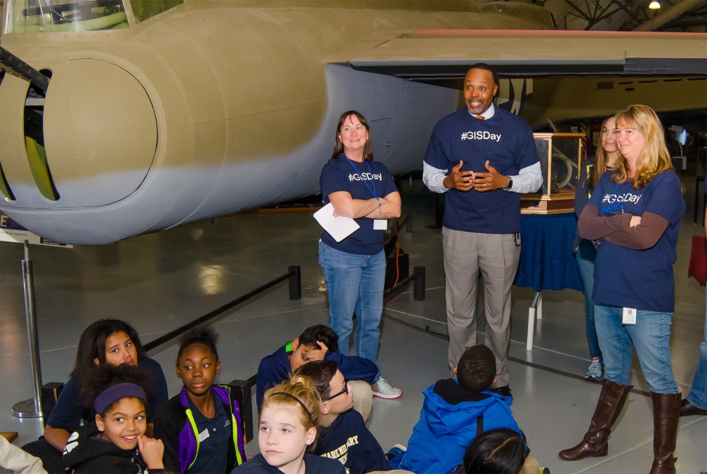
Kim Cloud, a software engineer at the Delaware Department of Technology and Information, told StateScoop over the phone that she was having trouble hearing the call over the noise of about 300 elementary school students who had just participated in a series of games and exhibits at the Air Command Mobility Museum in Dover as part of Delaware GIS Day. There was a big balloon shaped like a globe that students could go inside, educational games like GIS Jeopardy and organizers helped students draw connections between GIS technology and real-life jobs through use of the museum’s flight simulator.
The kids had a lot of fun, Cloud said, but ultimately GIS Day and all of the initiatives surrounding it represent a workforce effort for the state.
“We are working with [Delaware Technical Community College] and the University of Delaware to come up with a curriculum for elementary teachers to help them with geography education to get students introduced to the topic and hopefully get them interested in maybe doing GIS some day,” Cloud said.
Furthering the GIS workforce effort and also managing daily use of geospatial data and technologies has led Delaware to develop a Geoeducation Committee that Cloud said meets quarterly and represents a broad range of interests from private companies to education, state and local agencies. One of Cloud’s jobs with the state is to use an enterprise GIS system called FirstMap that provides standardized data layers to state agencies and local governments.
“We really have to work together so we’re all using the same data,” Cloud said. “You can’t have this industry without collaboration from multiple agencies and users.”
Hundreds of the events being held in the name of GIS Day are mapped on Esri’s GIS Day website.


