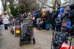
People wait in line as free food is distributed to residents in need at a weekly food bank at Our Lady of Refuge Church in Brooklyn on February 28, 2024 in New York City.(Spencer Platt / Getty Images)
Proposed cuts to food assistance threaten not only to harm food-insecure people, but deprive food banks of valuable data they need to serve their communities.
The software companies are merging their 2-D and 3-D data and geospatial technologies to provide cities with new capabilities that they say will inform richer insights, faster.
A new program attempts to bring structure to a widespread effort by states and municipalities to modernize their election systems using geospatial data.
As Detroit looks to tackle an array of urban ills, data visualization advocates are looking at bringing those issues into greater focus using data and mapping technology.