South Carolina streamlines broadband grant process using geospatial data

South Carolina’s broadband office says it has streamlined the deployment and management of broadband infrastructure projects throughout the state by integrating geographic information system data.
By developing an extensive geospatial data warehouse, officials with the broadband office are better able to identify and prioritize funding for areas throughout the state that lack a reliable internet connection, James Tanis, a senior geospatial data scientist with the state’s broadband office, said Thursday during a webinar hosted by the National States Geographic Information Council.
“When we started out we were going to let the [internet service providers] when they apply, just hand us back GIS data and after sitting down for a little bit we thought we’d better standardize the GIS data coming to us or else we’re just going to get slop, or just a bunch of different stuff from every single person that applies,” Tanis said.
The office created a template GIS dataset that directs applicants on how to present data while applying for grant projects, a data dictionary and a dictionary for all the South Carolina broadband office’s template files. He said the office also moved away from fillable PDFs for grant applications in favor of Excel forms to more efficiently convert data into a usable format.
“We can use formulas, we can chart the data when it comes in, we can graph it, we can quickly score, we can grab certain fields we want,” Tanis said. “In the end, instead of trying to strip it from a PDF file, now we have it in Excel.”
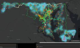
Once the office has reviewed all applications, census-block GIS data is published online as an interactive map for public viewing and awareness of what has been applied for.
The map also allows the broadband office to more easily score projects because internet service providers include information on line work, census blocks and network junctions, Tanis said. Once projects are selected for awards, the broadband office creates another map that includes the grant agreement and a table with GIS statistics, including the number of eligible service locations that will be served, miles of line work and what percentage of the work is aerial or underground.
When the project is finally underway, the broadband office continues to use GIS data to monitor the work in real time, he said.
“What we came up with was: Why not require the ISPs to submit geotagged construction photos and geotagged speed test photos to us during their quarterly reports?” Tanis said, noting that the reports also include details on how many homes were passed, how many miles of fiber have been installed and project timelines.
GIS data is also used to close out projects with ISPs, certifying their work on maps and a closeout checklist that tracks how many homes and businesses were passed, how many miles of fiber was installed and other details.
“With all of this and the data we have during the monitoring of the project … we feel confident at this point they have built the project to the specifications we have asked for, they have built it where they said they were going to build it, so it’s time to pay them at this point,” Tanis said.
One new area where the office has incorporated GIS data is its challenge portal for the federal Broadband Equity, Access and Deployment, or BEAD, program. States had the option of either building their own portals or buying one from a company. South Carolina chose to build its portal in-house and modeled it after similar processes they’d already developed for the broadband grant award process.
The portal includes a map of BEAD-eligible service locations throughout the state. People and organizations can submit challenges through an online survey form and argue whether or not areas are actually served.