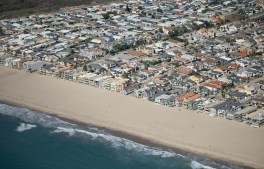
Oxnard, CA – October 05, 2026: Oxnard Shores photographed from an airplane on Monday, Oct. 5, 2026 in Oxnard, CA. Topographic LiDAR survey of the California coastline funded by the state of California monitors coastal erosion and morphology due to increasingly large storm and weather events along with rising sea levels. This survey serves as a baseline for future surveys and was conducted just before and after an active El Nino winter season.(Kayla Bartkowski / Los Angeles Times via Getty Images)
The National Oceanic and Atmospheric Administration has forecasted a 75% chance that this year’s El Niño will become a historic event, increasing the risk of high tide…
Cuts at the Federal Emergency Management Agency and the National Oceanic Atmospheric Administration could hinder state and local government coordination.
NOAA Fisheries’ Roy Varghese discusses how integrating modern technologies like AI, ML, data science to the lines of business helps build agility to meet crisis.