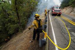
The state agency’s new Fire Innovation Unit will bring firefighters, IT specialists and researchers together to test whether emerging tools can address operational gaps and improve safety…
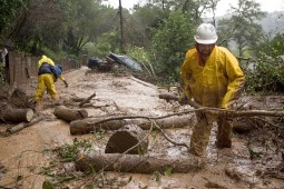
FAIRFAX, CA – JANUARY 2: Gilbert Velarde clears debris from a mudslide on Tamalpias Road January 2, 2006 in Fairfax, California. Northern California has been inundated by heavy rain over the past week, causing mudslides and pushing rivers over their banks. (Photo by David Paul Morris/Getty Images)
New federal grants from the U.S. Geological Survey are helping states build landslide databases that can improve hazard mapping, emergency planning and public awareness.
The partnership will focus on redesigning member notices, simplifying applications and mapping caseworker processes to identify repetitive tasks that could be automated or streamlined.
The latest grants from the Administration for Children and Families aim to help modernize background check systems to speed foster family licensing and child placements.
A new NASCIO and Forrester report finds state CIOs are balancing agency priorities, budget constraints and emerging technologies as they take on larger roles in IT investment…
The new tool will track shelter use, length of stay, demographics, people housed, program exits and destinations, exits without notice and participant deaths.
Keith Wilson, a talent engagement manager at the U.S. Digital Response, discusses the organization’s new Digital Service Toolkit and the evolution of digital service teams in state…
Gov. Gavin Newsom speaks onstage during the NYT Climate Forward 2025 at The Times Center on September 24, 2025 in New York City. (Yana Paskova / Getty Images for NYT)
The tool uses Anthropic’s Claude model and will rely on state subject matter experts to help validate responses from verified sources, rather than simply generate conversational answers…