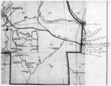
A map shared by Shasta County, California, officials during a presentation on May 6, 2021, reveals the typical pencil-and-paper processes that once defined elections operations in the local government. (Shasta County, California)
County officials said a recent pilot project with the National States Geographic Information Council gave them a boost in confidence and staff support.
Maricopa County, Arizona, which is home to more than 2.4 million voters, has used geospatial information systems to perfect its legislative and precinct maps, and grow voter…